AEC

Plex-Earth 2023 - Blockbuster Release!

Plex-Earth 2023: Our Biggest Blockbuster Ever!

Plex-Earth 2023 – it’s our biggest release… EVER!

First up is the debut of our newest rising star…

Introducing Inflights drone data – book custom flights!

Yes! For the first time ever, Plex-Earth brings you discounts on custom DRONE flights, with our little flying friends available almost anywhere on Earth!

Generating 2D orthomosaics, 3D models and maps can often have a higher degree of precision than traditional surveying methods. This game-changing development transforms Plex-Earth into a mandatory tool, not only for your early design stages, but for all design and even the later construction stages!

You just select the target area and pick your options from within Plex-Earth. You’ll soon receive a fast and firm quotation from a local independent pilot – and your Plex-Earth discount!

Your order activates the Inflights platform, which can obtain, process and analyze imagery and data from a global network of independent drone pilots and their equipment. This brings you consistent results with expert processing and analysis, while smartly avoiding the usual hassles of trying to arrange your own equipment or permits

It’s (nearly) all the fun of flying your own drone, without the flip-sides!

Orthomosaic expertise - multiple high-res’ drone images stitched together for you!

See our joint press release here: Drone data in AutoCAD: Plex-Earth and Inflights

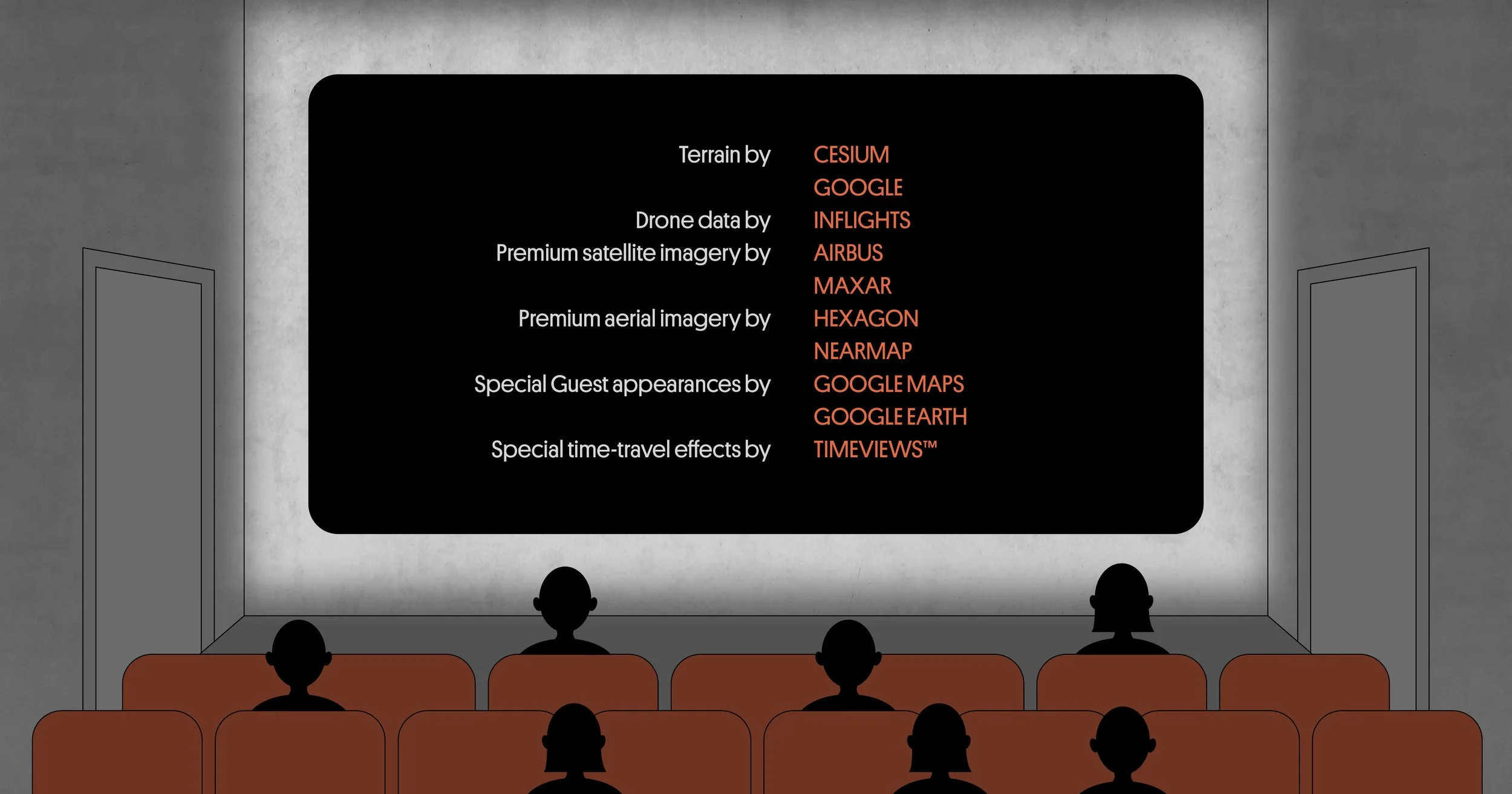
Co-starring Cesium, a rising star in global 3D terrain!

Analytical Graphics Inc. went on a mission to produce the most accurate digital 3D version of our planet – all of it – ever created. The results are impressive!

Plex-Earth still offers terrain data from Amazon and Google Earth, but also introduces Cesium. Now you can choose from the unique characteristics of each provider, picking the best option for the different stages of your project, including the risks to avoid or the people you need to impress!

Importing 3D terrain into AutoCAD is now much improved, with:

  • Google Earth, Terrain Tiles (AWS) and now Cesium!

  • Fewer clicks

  • More features

  • Faster processing - much faster!

  • Global coverage of 3D terrain

  • Mesh points or contours, you’ve got it all!

  • Effortlessly imported onto your AutoCAD .dwg

  • Terrain analysis made easy (see tutorial link below)

  • Resolution varies by location, from 30 meters down to 50 cm!

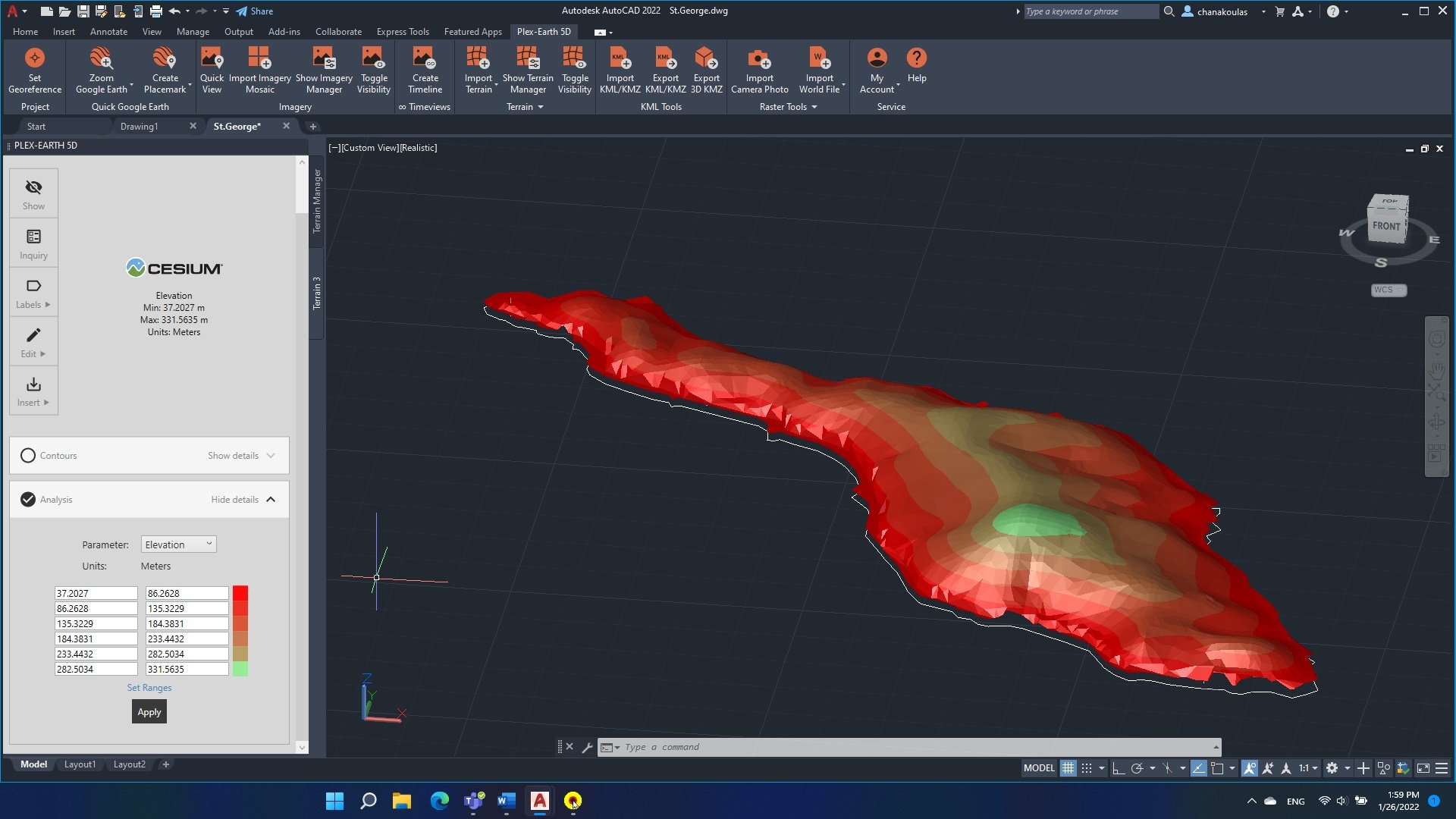
Rising star Cesium is already winning the hearts of engineers!

See more here: Importing terrain into AutoCAD tutorial

Time-Travel Special Effects by TimeViews™!

It wouldn’t be a blockbuster without a superpower or some special effects, and in Plex-Earth 2023 the hero – that’s YOU – can travel back in time!

A timeline of historical satellite imagery inside AutoCAD let’s you see what’s stayed the same, changed or is still changing, with:

  • Worldwide coverage!

  • Various datasets available

  • High-quality and high-resolution from Airbus and Maxar

  • Spanning as long as 10 years or as recent as a few days ago!

This is the Arena MRV in Brazil, during construction.

Note that because this is real imagery, for best results you can select periods without cloud cover!

See more about Plex-Earth Timeviews

Talking about timeliness and being up-to-date…

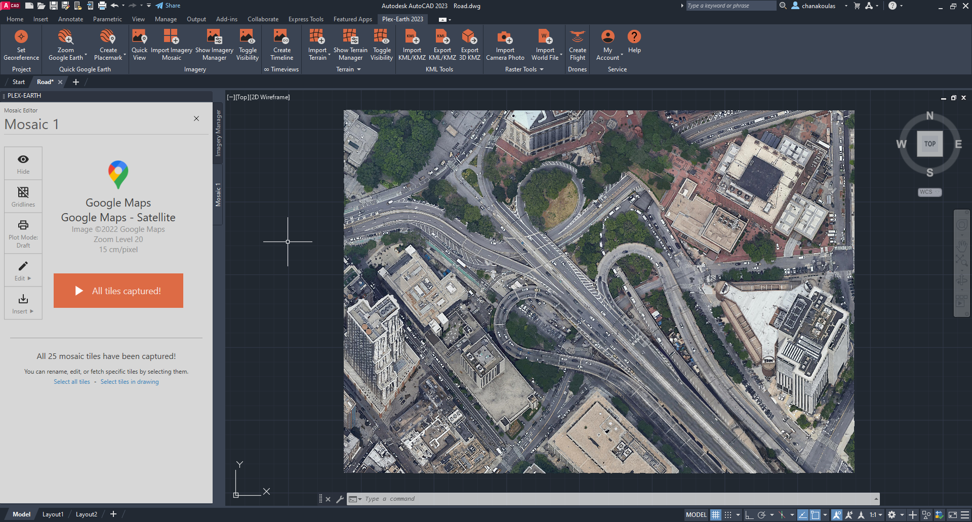
Putting premium satellite and aerial imagery in AutoCAD: Maxar, Airbus, Hexagon and Nearmap!

Satellite imagery doesn’t have to be Bing!

With global coverage, imagery that can be just a few days old and resolutions down to 30cm, Maxar or Airbus can take your satellite image background to the next level!

It’s not hard to tell which image is most up to date…

With Plex-Earth 2023:

  • Static raster image – no flickering or reloading every time you zoom

  • Static images also avoid over-consumption of premium imagery

  • Multiple-image mosaics, to cover large areas at high resolution

  • Most areas only weeks old, not months or years!

  • Resolutions down to 50 or even 40 cm satellite

  • Resolutions down to 30, 15 or even 7.5 cm aerial

You can see the bigger picture with satellites, while our aerial imagery from Nearmap and Hexagon can reveal the finer details across the US, Australia, Canada and the urban areas of New Zealand.

How fine? Depending on the supplier and area it can be 30cm, 15cm, even 7.5cm resolution!

Special Guest Appearance: Google Maps and Google Earth

Yes, the crowd-pleasing Google Twins return to your big AutoCAD screen!

Google Earth + AutoCAD = easy with Plex-Earth 2023!

Exporting objects into Google Earth is another crowd-pleaser that returns to grace the big screen!

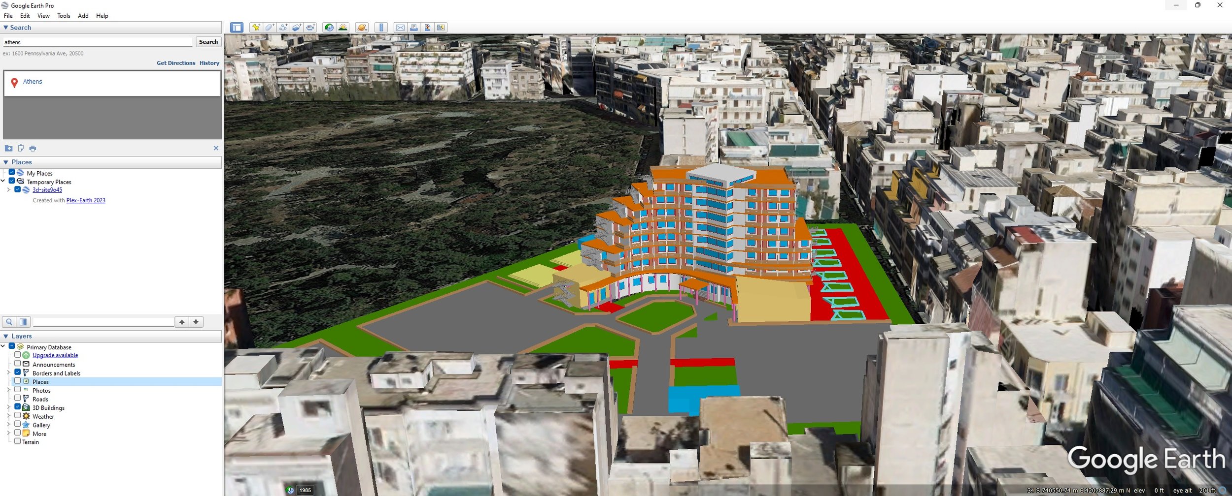
Exporting from AutoCAD into Google Earth is easy with Plex-Earth!

Updating from Plex-Earth 4.0?

Plex-Earth 2023 offers you everything you love about 4.0, including the return of the Google Earth goodness, while offering you even more flexibility and power!

As a current Plex-Earth 4.0 user you’re entitled to extra-special assistance when stepping up to this new platform, including booking a free Teamviewer session where we’ll walk you through the differences. We even have a special PE4 to PE2023 transition tutorial just for you!

Functional free trial? Of course!

Most movies only last around 90 minutes; our free trial lasts 7 whole days and yes you can use Plex-Earth 2023 on a real project, right now!

Compatibility with AutoCAD 2023

Game changing companies look forward and being one step ahead is always a plus. Plex-Earth 2023 offers full compatibility with the just released AutoCAD 2023, as well as with its most popular verticals (Civil 3D, Map 3D, Architecture, Mechanical, Steel).

Plex-Earth 5D: Plexscape launches new platform during Autodesk University 2021 - Taking the guesswork out of civil design

Plex-Earth 5D: Plexscape launches new platform during Autodesk University 2021 - Taking the guesswork out of civil design

Plexscape, developers of Plex-Earth, a full-blown popular platform for AutoCAD that brings the world’s largest aerial and satellite imagery providers under a single umbrella, participates again in this year’s Autodesk University as a premier sponsor.

Plexscape will be officially launching Plex-Earth 5D, its latest most powerful version during Autodesk University, as it is the year’s biggest event for the Architecture, Engineering and Construction (AEC) industry.

Plex-Earth 5D: You Got What You Asked For!

Plex-Earth 5D: You Got What You Asked For!

Yes, we listened!

Google Maps into AutoCAD, AutoCAD objects into Google Earth, premium updated imagery providers; it's all great stuff but PERFECTION – and thus Plex-Earth - are always a work in progress!

The world's top engineers know that at Plexscape we frequently run surveys and even live interviews to make sure the projects we're working on are more than what you need, but what you (really really) want.

The new Plex-Earth is here: AutoCAD 2022 support, advanced image capabilities and more

The new Plex-Earth is here: AutoCAD 2022 support, advanced image capabilities and more

The term “continuous improvement” is fairly self-explanatory and widely used for any product or service, but when it comes to software it’s vital.

Being humbled by the massive support of the AutoCAD engineering community since Plex-Earth was born 11 years ago, our software is now on its 5th generation and its latest release comes with a number of important improvements, also supporting AutoCAD 2022!

As Heather Miller writes on the official AutoCAD blog:

“For years, many people have relied on Plexscape’s Plex-Earth to view Google Earth images in AutoCAD. Now, the company has released an incredible update to the plug-in that includes high-resolution aerial and satellite imagery from Airbus, Maxar, Nearmap, and more.”

Plex-Earth expands to BricsCAD to empower AEC professionals with premium satellite and aerial imagery 

Plex-Earth expands to BricsCAD to empower AEC professionals with premium satellite and aerial imagery 

Plex-Earth, a full-blown popular platform for AutoCAD that brings the world’s largest aerial and satellite imagery providers under a single umbrella, now expands its offering to BricsCAD, to inform smart engineering with recent, historical, high-quality imagery and terrain data.

Locating your project area in a blank drawing - AutoCAD 2021

The following question recently arrived at our support team’s mailbox:

I know the coordinate system and my project’s location in Google Earth, but how can I find its exact position in a blank drawing?

Up until Plex-Earth 4, there was a command that allowed you to synchronize AutoCAD with the current view in Google Earth. It was one of the first commands developed in Plex-Earth back in 2008, and it was the base of more advanced functions (such as imagery mosaic importing). However it’s not directly available anymore due to the discontinuation of Google Earth's COM API.

But as we've already said, we accepted the challenge, and instead of downgrading functionality due to Google Earth’s changes, we instead took it as an opportunity to enhance the existing functionality, actually making it more meaningful and more useful than ever!

We improved that humble AutoCAD - Google Earth sync command by adopting the copy & paste functionality of Google Earth objects as a part of other commands, making them easier to use and more complete.

So, regarding the original question, you can choose between two simple ways/methods:

Method 1: Locate your project area in Google Earth. Create a placemark, path or polygon (any will work), copy it, and then simply paste it (Ctrl-V) in AutoCAD.

Plex-Earth will automatically do the rest and will zoom AutoCAD drawing to your project area.

Sounds almost too simple to be true, but Plex-Earth is smart enough to figure it out, and will automatically zoom the AutoCAD drawing to your project area for you! See the video below.

Method 2: Locate your project area in Google Earth, create a placemark (or other objects), copy it, and return to AutoCAD.

Click the "Import Imagery" button in Plex Earth 5 ribbon, select to import Simple Image, and choose Google Maps (or any other provider) on the next screen.

Again, Plex- Earth will do the rest and import an image to your project location.

Method 2 means you not only zoom your drawing to a specific geographic location, but you also import useful objects that can help you better identify and understand your project area.

Videos are good but wanna check it yourself, with a real project? Start your 7-day UNRESTRICTED free trial and experience Plex-Earth’s full capabilities in the next few minutes!

Why we're burning our brand on purpose - and good riddance 2020!

Why we're burning our brand on purpose - and good riddance 2020!

Think of it as burning our boat!

The world has a number of boat (and bridge) burning festivals and folk-sayings, but here I'm referring to the English expression, probably based on the example of Spanish Conquistador Hernán Cortés...

In the early 16th century he arrived in what is today Mexico, upon which he ordered his crew to burn the ships they arrived on, deliberately destroying any option of retreat!

That's an extreme example, and perhaps more daring than changing our company look and logo, but we changed our logo with the same fighting spirit!

So what exactly did we do, and why?

Satellite imagery in AEC – what’s wrong with Bing, and what's so unique about Plex-Earth 5?

Satellite imagery in AEC – what’s wrong with Bing, and what's so unique about Plex-Earth 5?

If you somehow missed the excitement around the launch of Plex-Earth 5 at last month's Autodesk University, and now keep hearing about version 5? Well this short blog post will help explain what all the buzz is about!

The first big change is not the nifty new logo – nice as it is and more about that in a next post – but that Plex-Earth is now a multiple-provider platform.

Plexscape and Airbus join forces to offer the best satellite imagery to the AEC industry

Plexscape and Airbus join forces to offer the best satellite imagery to the AEC industry

Following a partnership between Plexscape and Airbus, engineers using AutoCAD can now have easy and fast access to OneAtlas, the Airbus’ geospatial digital platform delivering the freshest satellite imagery, through the new version of Plex-Earth.

By getting access to recent imagery, engineers get a complete understanding of their project sites' conditions from the very beginning of their design workflow, speeding up processes and avoiding the high cost of rework by reducing errors.

New Satellite & Aerial Imagery Platform launched by Plexscape during Autodesk University Conference - Going beyond Google Earth

A dramatic update of popular AutoCAD imagery plugin Plex-Earth launches at this year’s online-only Autodesk University, switching from just Google Earth to images from top imagery providers Airbus, Maxar, Nearmap And Hexagon.

Plexscape’s response to COVID-19 pandemic: Free Plex.Earth licences for remote working

Plexscape’s response to COVID-19 pandemic: Free Plex.Earth licences for remote working

In response to COVID-19 pandemic, Plexscape, developers of Plex.Earth®, one of the most popular AutoCAD tools for the acceleration of architectural, engineering and construction (AEC) projects, is doubling its customers’ licenses at no extra cost, for the next 3 months.
This initiative aims to help thousands of Plex.Earth users in more than 120 countries worldwide to have a smooth transition to the new remote-work conditions by installing the software on their home computers or laptops, free of charge.

We're here for you: Free Plex.Earth activations during COVID-19 pandemic

We're here for you: Free Plex.Earth activations during COVID-19 pandemic

Seeing how bad the COVID-19 situation seemed to be we arranged for our own staff to work remotely, but we wondered, could we help and encourage YOU, our Plex.Earth users, to do the same? Consequently, we decided to double your Plex.Earth licensed machines, without any extra charge, for the next 3 months.

Plex.Earth Timeviews™ empowers AEC professionals with the latest satellite imagery within AutoCAD

Plex.Earth Timeviews™ empowers AEC professionals with the latest satellite imagery within AutoCAD

Plexscape, developers of Plex.Earth®, one of the most popular tools for AutoCAD for the acceleration of architectural, engineering and construction (AEC) projects, launched Timeviews™, a unique service in the global AEC market, which makes the most up-to-date satellite imagery affordable and easily accessible within AutoCAD.

Introducing Plex.Earth Timeviews™: View the most up-to-date satellite imagery in AutoCAD

How many times did you wish you could have the current view of your project area? Outdated imagery can lead to costly design mistakes. Not anymore.

We have launched Plex.Earth Timeviews™, our new premium service, which brings Bird.i's up-to-date satellite imagery from DigitalGlobe, Airbus and Planet into your designs. Now you can get the most current view of your project area for any place in the world (you can read more here).

To guide you through Timeviews™, we have prepared a tutorial to show you how easy is to view the newest satellite imagery into your AutoCAD designs, for any project in the world.

Do you want to get free and unlimited access to Timeviews™ until the 31st of August?

We have an exclusive offer currently running for our amazing customers and anyone who wants to grab a new Plex.Earth subscription now!

Just make sure you download the newest version of Plex.Earth and follow the in-app instructions.

The story behind Plex.Earth: Taking the guesswork out of civil design

The story behind Plex.Earth: Taking the guesswork out of civil design

You have just won your next project and can't wait to create a model for your design. You have been in that position, right? Then, you know it: the whole process can be a cumbersome, time-consuming and prone to errors experience.

In 2009, Lambros Kaliakatsos, Plexscape founder & CEO, being a CAD manager back then, got a bitter taste of the difficulties designing without having the complete real-world view of his sites, anytime he needed it.

Having experienced the high cost of rework on projects he was responsible for, he decided to do something about it.

So, in case you wonder, here’s our story, as published in the TwinGEO magazine by the popular blog Geofumadas!

Copy KML/KMZ objects from Google Earth to AutoCAD with Plex.Earth

We have introduced a powerful new feature in the latest version of Plex.Earth 4, which allows you to import objects from Google Earth into AutoCAD with a simple copy and paste operation.

You can even import KMZ elements that are loaded dynamically into Google Earth!

Interested to find more? Read our tutorial here.


How to create live tours in Google Earth, for your AutoCAD design, with Plex.Earth

How to create live tours in Google Earth, for your AutoCAD design, with Plex.Earth

Showcasing your AutoCAD design to Google Earth and sharing it with others can be vital for your project: Winning that customer, taking instant feedback, convincing local authorities/communities and shareholders for your design.

What about not just exporting your design but also creating realistic videos and immersive live tours in Google Earth?

We have created a tutorial to show you how you can easily do that with Plex.Earth to engage anyone you want from the early stages of your design, reducing subsequent and unproductive iterations that cost you time and money.

Plex.Earth is featured on DigitalGlobe's official blog

Data is the new oil, don’t you think? We firmly believe so!

Our new partnership with Bird.i is based on our shared vision to bring the value of the most up-to-date satellite imagery to businesses of any size for better -informed decision making (you can read our joint press release and visit our page for more information).

Corentin Guillo, Bird.i CEO, has written a great guest post on DigitalGlobe company blog about our partnership, explaining the real value it brings to the Architecture, Engineering and Construction (AEC) industry.

DigitalGlobe is a leading provider of high-resolution Earth imagery, data and analysis, owning and operating an agile and sophisticated constellation of
high--resolution commercial Earth imaging satellites.

Read the guest post here and watch this space for more news and updates regarding this powerful partnership.