Google Earth

Plex-Earth 5D: Plexscape launches new platform during Autodesk University 2021 - Taking the guesswork out of civil design

Plex-Earth 5D: Plexscape launches new platform during Autodesk University 2021 - Taking the guesswork out of civil design

Plexscape, developers of Plex-Earth, a full-blown popular platform for AutoCAD that brings the world’s largest aerial and satellite imagery providers under a single umbrella, participates again in this year’s Autodesk University as a premier sponsor.

Plexscape will be officially launching Plex-Earth 5D, its latest most powerful version during Autodesk University, as it is the year’s biggest event for the Architecture, Engineering and Construction (AEC) industry.

Plex-Earth expands to BricsCAD to empower AEC professionals with premium satellite and aerial imagery 

Plex-Earth expands to BricsCAD to empower AEC professionals with premium satellite and aerial imagery 

Plex-Earth, a full-blown popular platform for AutoCAD that brings the world’s largest aerial and satellite imagery providers under a single umbrella, now expands its offering to BricsCAD, to inform smart engineering with recent, historical, high-quality imagery and terrain data.

Locating your project area in a blank drawing - AutoCAD 2021

The following question recently arrived at our support team’s mailbox:

I know the coordinate system and my project’s location in Google Earth, but how can I find its exact position in a blank drawing?

Up until Plex-Earth 4, there was a command that allowed you to synchronize AutoCAD with the current view in Google Earth. It was one of the first commands developed in Plex-Earth back in 2008, and it was the base of more advanced functions (such as imagery mosaic importing). However it’s not directly available anymore due to the discontinuation of Google Earth's COM API.

But as we've already said, we accepted the challenge, and instead of downgrading functionality due to Google Earth’s changes, we instead took it as an opportunity to enhance the existing functionality, actually making it more meaningful and more useful than ever!

We improved that humble AutoCAD - Google Earth sync command by adopting the copy & paste functionality of Google Earth objects as a part of other commands, making them easier to use and more complete.

So, regarding the original question, you can choose between two simple ways/methods:

Method 1: Locate your project area in Google Earth. Create a placemark, path or polygon (any will work), copy it, and then simply paste it (Ctrl-V) in AutoCAD.

Plex-Earth will automatically do the rest and will zoom AutoCAD drawing to your project area.

Sounds almost too simple to be true, but Plex-Earth is smart enough to figure it out, and will automatically zoom the AutoCAD drawing to your project area for you! See the video below.

Method 2: Locate your project area in Google Earth, create a placemark (or other objects), copy it, and return to AutoCAD.

Click the "Import Imagery" button in Plex Earth 5 ribbon, select to import Simple Image, and choose Google Maps (or any other provider) on the next screen.

Again, Plex- Earth will do the rest and import an image to your project location.

Method 2 means you not only zoom your drawing to a specific geographic location, but you also import useful objects that can help you better identify and understand your project area.

Videos are good but wanna check it yourself, with a real project? Start your 7-day UNRESTRICTED free trial and experience Plex-Earth’s full capabilities in the next few minutes!

The story behind Plex.Earth: Taking the guesswork out of civil design

The story behind Plex.Earth: Taking the guesswork out of civil design

You have just won your next project and can't wait to create a model for your design. You have been in that position, right? Then, you know it: the whole process can be a cumbersome, time-consuming and prone to errors experience.

In 2009, Lambros Kaliakatsos, Plexscape founder & CEO, being a CAD manager back then, got a bitter taste of the difficulties designing without having the complete real-world view of his sites, anytime he needed it.

Having experienced the high cost of rework on projects he was responsible for, he decided to do something about it.

So, in case you wonder, here’s our story, as published in the TwinGEO magazine by the popular blog Geofumadas!

Copy KML/KMZ objects from Google Earth to AutoCAD with Plex.Earth

We have introduced a powerful new feature in the latest version of Plex.Earth 4, which allows you to import objects from Google Earth into AutoCAD with a simple copy and paste operation.

You can even import KMZ elements that are loaded dynamically into Google Earth!

Interested to find more? Read our tutorial here.


Free webinar: 3D vehicle simulations in Google Earth with Plex.Earth and AutoTURN Pro

Looking to publish your 3D vehicle simulations in Google Earth?

We’re hosting a free webinar with our trusted partners, Transoft Solutions, to show you how you can do this easily and quickly, with Plex.Earth and AutoTURN Pro.

Join this webinar to learn how to import the most up-to-date satellite imagery, create swept path analyses and display the end result in Google Earth.

The benefits are numerous:

► You can share breathtaking presentations with anyone you want.
► Take instant feedback whenever you need it to meet your project deadlines.
► Impress your clients and land new ones.

Plex.Earth and AutoTURN Pro live webinar
Date: Thursday, June 13, 2019
Time: 10:00 AM PT | 12:00 PM CT | 18:00 PM CET
Hosts: Nicolas Paraskevopoulos, Customer Support Specialist at Plexscape
Majo Varghese, Sales Consultant at Transoft Solutions


How to create live tours in Google Earth, for your AutoCAD design, with Plex.Earth

How to create live tours in Google Earth, for your AutoCAD design, with Plex.Earth

Showcasing your AutoCAD design to Google Earth and sharing it with others can be vital for your project: Winning that customer, taking instant feedback, convincing local authorities/communities and shareholders for your design.

What about not just exporting your design but also creating realistic videos and immersive live tours in Google Earth?

We have created a tutorial to show you how you can easily do that with Plex.Earth to engage anyone you want from the early stages of your design, reducing subsequent and unproductive iterations that cost you time and money.

How to create terrain contours with Plex.Earth

contours plexearth .jpg

With Plex.Earth 4, you can visualize terrain morphology with elevation contours and import thousands of terrain elevation points into AutoCAD, automatically and incredibly quickly.

We have created a detailed tutorial to guide you through the process of creating contours easily with Plex.Earth 4.

For a detailed guide on how to import terrain, check our post on our support section.

You are one step away from focusing on what matters most: your design. Start your free trial today and watch this space for more!

How to export object information to Google Earth with Plex.Earth

Presentation2.jpg

When it comes to your design, the devil is in the details. Plex.Earth 4 allows you to export even the most complex 3D models to Google Earth and visualize materials like bricks and textures.

You can even add object data to your elements (both as plain text and in an HTML format), which can then be exported to Google Earth with your AutoCAD drawing.

This way you can share information with your colleagues, customers, anyone you want, let everyone understand your designs and take instant feedback, keeping your project on time and on budget.

We’ve put together a detailed tutorial on how to do this in a few simple steps with Plex.Earth 4. Read it here and start your free trial today!

Lineweight options when exporting AutoCAD drawings to Google Earth

Do you want to assign lineweights to the polylines that you export to Google Earth, as KML/KMZ files?

Normally, when you publish elements, they attach to Google Earth in only one size by default (1 Google Earth unit) and they do not change when zooming in or out.

Plex.Earth 4 allows you to define lineweights to your drawings choosing from constant width, multiplier and physical scale.

Read our detailed tutorial for more and start your free trial today!


How to create imagery and terrain corridors with Plex.Earth 4 (roadwork/railroad projects)

final2.jpg

Looking to import imagery/terrain along a corridor into AutoCAD for your roadwork or railroad project?

We have prepared a tutorial to show you how to do this, with Plex.Earth 4, easily and quickly: By choosing to import imagery using the “By Path” option, you can decrease the import time significantly and boost your productivity.

Check it out and watch this space for more tutorials and helping materials!


Bagging the big ones in Africa, while safe and comfortable in your home office?

Bagging the big ones in Africa, while safe and comfortable in your home office?

How fast and accurately could you draw a preliminary design for a 60 kilometer road project (and a bridge) in Zambia, Central Africa?

That was the real-world challenge faced by Graham Demmer, of HHO Consulting Engineers, nearly 2,000 km away in South Africa’s Cape Town.

Plex.Earth and AutoTURN PRO free webinar: How to create the most realistic 3D vehicle simulations in Google Earth

Plexscape has partnered with Transoft Solutions allowing engineers and designers to create and share impressive presentations of their swept path analysis into Google Earth.

Following the integration of their popular software, Plex.Earth and AutoTURN PRO alike, the two companies announce their first free webinar which will take place on Thursday 13th of December at 11:00 AM CET (12:00 GMT+2 or EET).

Those who are interested can register here.

This in-depth training run by in-house specialists of both software will show engineers and designers how to import high-quality satellite imagery, create swept path analysis and display the end result in the Google Earth environment.

The attendants will have the opportunity to experience first-hand the value of bringing together Plex.Earth with AutoTURN technology, as shown in this video.

According to “Make it, or break it - Global Construction Survey 2017” by KPMG, companies still struggle to deliver projects on time and within budget.

However, by publishing their 3D vehicle content in Google Earth, engineers now have a powerful tool in their hands: they can create and share breathtaking presentations with their customers or colleagues and take instant feedback, whenever they need it. Therefore, they can reduce revisions and meet their project’s deadlines and budget goals.

All registrants will receive a full recording of the presentation, so they can sign up even if they’re not sure they can attend.

Plex.Earth and AutoTURN PRO webinar
DATE: Thursday, December 13, 2018
TIME: 11:00 CET (12:00 GMT+2 or EET).
HOSTS: David Homola, Product Manager at Transoft Solutions EMEA,
Nicolas Paraskevopoulos, Customer Support Specialist-Civil Engineer at Plexscape

About Plexscape

Plexscape is a software company committed to changing the way engineers work on Architectural, Engineering, and Construction (AEC) projects, by developing innovative solutions that bridge the gap between design and the real world.

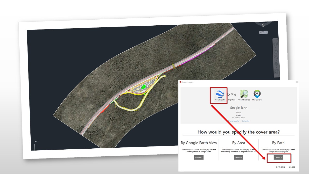
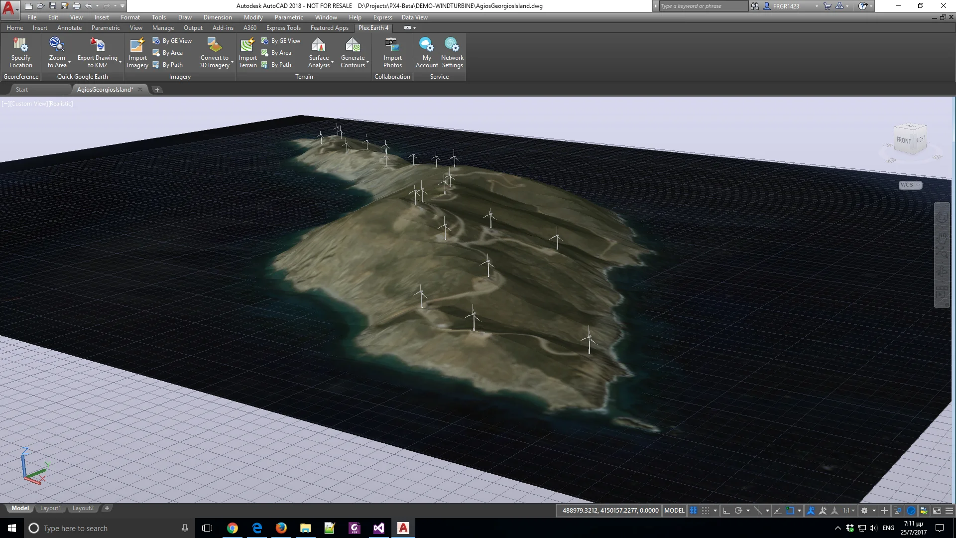
Plex.Earth, our flagship product, is the first cloud-based software ever created in the CAD market and one of the most popular tools in the Autodesk App Store.

Our solution, originally released in 2009, is being used by more than 15,000 engineers in over 120 countries worldwide, enabling them to have the complete 3D geographical view of their real-world project sites within minutes, through Google Earth and other satellite data providers. For more information on Plex.Earth's benefits, visit www.plexearth.com.

About Transoft Solutions

Transoft Solutions develops innovative and highly specialized software for aviation, civil infrastructure, and transportation professionals. Since 1991, Transoft has remained focused on safety-oriented solutions that enable transportation professionals to design with the utmost confidence. Our portfolio of planning, simulation, modeling, and design solutions, are used in over 130 countries serving more than 50,000 customers across local and federal agencies, consulting firms, airport authorities, and ports. We take pride in providing best-in-class customer support from our headquarters in Canada, and through offices in Sweden, the United Kingdom, Netherlands, Australia, Germany, India, Belgium, and China.

For more information on Transoft’s range of trusted and field-tested engineering software, visit www.transoftsolutions.com/emea.


Plexscape joins forces with Transoft Solutions

Since the creation of Plex.Earth in 2009, we have been committed to changing the way engineers work on Architectural, Engineering and Construction (AEC) projects, by bridging the gap between design and the real-world.

Following through on our commitment, we are excited to announce our partnership with Transoft Solutions, a global leader in transportation engineering design and analysis software.

Central to the partnership is integrating AutoTurn with Plex.Earth, allowing engineers and designers to demonstrate vehicle swept path analyses directly into Google Earth.

By creating and sharing self-explaining presentations in the Google Earth environment, engineers can make design decisions with more confidence, reduce revisions and keep their projects on time and on budget.

Do you want to know what Plex.Earth can do for you? Start your free trial now and stay tuned for more!

The mind-blowing experience of a civil engineer with Plex.Earth 4

The mind-blowing experience of a civil engineer with Plex.Earth 4

Every software performs well in the lab, but beta testing offers a company crucial insight into how its users interact with the product in real-world settings. In our case, putting Plex.Earth 4 in beta mode was a strategic decision. One of our beta testers, Myles Russel, Senior Civil Coordinator at Farrell's Excavating Limited, got his hands dirty testing our software and gave us an interview describing his great experience with Plex.Earth 4!

Plex.Earth: Import 3D terrain and imagery from Google Earth to AutoCAD

Plex.Earth: Import 3D terrain and imagery from Google Earth to AutoCAD

For the last months, our development team has been very busy in building the new version of our flagship product, Plex.Earth 4.

We're all excited having added some unique features to our software, and although our new version is in beta version, we would like to share a sneak peek at these new capabilities.